Donate
  • Events
  • Contact
  • Join Our Mailing List
  • Facebook
  • Instagram
  • LinkedIn
  • YouTube

Hilltown Land Trust

Dedicated to protecting the working lands, native habitats and rural beauty of the Hilltowns since 1986

  • About
    • Board & Committees
    • Staff and TerraCorps members
    • Affiliation with The Trustees
    • Announcements
    • Newsletters
    • Contact
    • Open Positions
  • Land Protection
    • Conservation Restrictions
    • Agricultural Preservation Restrictions
    • Financial Incentives
    • Donating or Selling Land
    • Estate Planning
    • Landowner & Town Resources
  • Properties
    • Trails & Maps
      • Big View Trail
      • Bradley
      • Breckenridge
      • Clary Hill
      • Conwell
      • Hilltown Boulders
      • Historic Dam Trail
      • Locke’s Loop Trail
      • Robert’s Meadow Brook Trail
      • Round Top Hill
      • Stevens
      • Two Mamas Farm Waterfall Trail
    • Land Stewardship
    • Conservation Stories
  • Get Involved
    • Events
    • Volunteer
    • Donate
    • Support
    • Legacy Giving
    • Gorge après Gorge
    • Vernal Pool Plunge
You are here: Home / Protected Lands post archive / Hiking Trails and Maps / Clary Hill

Clary Hill

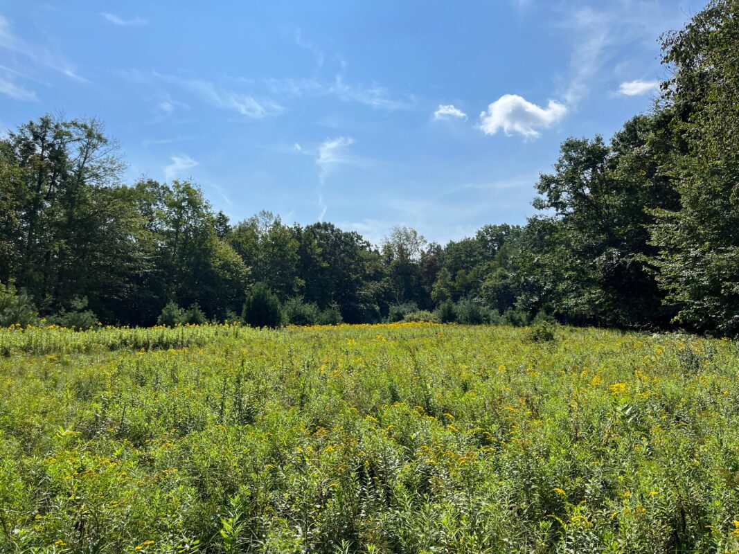
A field of goldenrod, framed by a dark green line of trees and blue sky.

The meadow at Clary Hill.

Enjoy opportunities for new adventures on the trails of Clary Hill and neighboring Briar Hill. Rolling and sometimes steep and rugged nested-loop trails and spurs take you across a dynamic range of habitat types and features, including stone steps and walls, rocky jumbles, lush wetlands, an oak-hickory glade blanketed with sedge, a crossing of the Cold Brook, and the scenic Briar Hill overlook with views reaching to Mt Tom.

Four warmly dressed volunteers gather on a long stone staircase in the woods.

A volunteer effort

Nearly 30 volunteers spent over 700 hours building the Clary Hill trails, contributing:

  • Stone staircases
  • Wooden bog bridges
  • Erosion-resistant graded trail surfaces

Photo: Members of the Williamsburg Woodland Trails Committee.

Trails

The 0.8-mile Briar Hill loop is marked with Williamsburg Woodland Trails medallions and yellow blazes. The 2 miles of trails on Clary Hill, including the Farm Lane, Meadow Loop, and The Ledges Trail are blazed in light blue. The Pines Link and Mossy Link between Clary Hill and Briar Hill are blazed in yellow.

Note that there are no restrooms or other facilities at this location.

Dog Safety

Dogs on leash are welcome on the trails. Clary Hill is rich with wildlife, including moose, bear, porcupines, and sensitive wetlands and habitats. For the safety of your pets as well as the plants and animals that call these hills home, dogs must be on leash during your visit.

Property Guidelines

The trails are open to the public following property guidelines: 

  • Dogs must be leashed at Clary Hill. Owners must remove pet waste from the property.
  • Hunting is not permitted.
  • No camping or fires.
  • No motorized vehicles.
  • Please respect sensitive habitat and remain on maintained trails.

Public access is open from dawn until dusk.

A view of the distant Holyoke Range mountains from the top of Briar Hill/Clary Hill.

Trail Map

A thumbnail image of the Clary Hill trail map.

Trail map of Clary Hill and Briar Hill. Click for a larger version.

Clary Hill Trail Map

Parking & Directions 

The trail network at Clary Hill and Briar Hill has two trailheads along Briar Hill Road on the Williamsburg-Goshen town line. From the center of Williamsburg, travel 1 mile west on Route 9 and turn right onto Old Goshen Road. Continue for 0.4 mi, then another 0.8 mi when it turns into Hemenway Road. Bear left on Briar Hill Road. The first trailhead (Briar Hill) will be on your right after 1.7 mi, and the second trailhead (Clary Hill) will be on your right after another 0.5 mi.

Note: Do not rely on Google Maps or GPS for directions! It may try to route you through several roads which are closed or impassable for much of the year. If your GPS is taking you through the DAR State Forest or points north, reroute to the above directions.

Silhouettes of the HLT logo bear and cub.

Events Calendar

Today
Sun
Mon
Tue
Wed
Thu
Fri
Sat
S
M
T
W
T
F
S
30
31
1
2
3
4
5
6
7
8
9
10
11
12
13
14
15
16
17
18
19
20
21
22
23
24
25
26
27
1:00 PM - Clary Hill Trail Opening Hike
28
29
30
1
2
3
Clary Hill Trail Opening Hike
Apr 27th, 2025    
1:00 pm - 3:00 pm
Clary Hill
  • Family Fun
  • Hike
**RESCHEDULED TO SUN. APRIL 27TH DUE TO WEATHER** Celebrate the opening of HLT’s newest trails at Clary Hill with a 2-mile hike! Explore the meadow, [...]
More Info
Events on Apr 27th, 2025
Clary Hill Trail Opening Hike
27 Apr 25
Goshen
  • About
    • Board & Committees
    • Staff and TerraCorps members
    • Affiliation with The Trustees
    • Announcements
    • Newsletters
    • Contact
    • Open Positions
  • Land Protection
    • Conservation Restrictions
    • Agricultural Preservation Restrictions
    • Financial Incentives
    • Donating or Selling Land
    • Estate Planning
    • Landowner & Town Resources
  • Properties
    • Trails & Maps
      • Big View Trail
      • Bradley
      • Breckenridge
      • Clary Hill
      • Conwell
      • Hilltown Boulders
      • Historic Dam Trail
      • Locke’s Loop Trail
      • Robert’s Meadow Brook Trail
      • Round Top Hill
      • Stevens
      • Two Mamas Farm Waterfall Trail
    • Land Stewardship
    • Conservation Stories
  • Get Involved
    • Events
    • Volunteer
    • Donate
    • Support
    • Legacy Giving
    • Gorge après Gorge
    • Vernal Pool Plunge

Learn

  • Announcements
  • Staff and TerraCorps members
  • Contact

Participate

  • Events
  • Volunteer
  • Donate
  • Subscribe

Hike

  • Bradley
  • Breckenridge
  • Stevens
Land Trust Accreditation seal
Contact Us
admin: Log in
© 2025 Hilltown Land Trust | Hilltown Land is a 501c3 nonprofit organization | Est. 1986