Donate
  • Events
  • Contact
  • Join Our Mailing List
  • Facebook
  • Instagram
  • LinkedIn
  • YouTube

Hilltown Land Trust

Dedicated to protecting the working lands, native habitats and rural beauty of the Hilltowns since 1986

  • About
    • Board & Committees
    • Staff and TerraCorps members
    • Affiliation with The Trustees
    • Announcements
    • Newsletters
    • Contact
    • Open Positions
  • Land Protection
    • Conservation Restrictions
    • Agricultural Preservation Restrictions
    • Financial Incentives
    • Donating or Selling Land
    • Estate Planning
    • Landowner & Town Resources
  • Properties
    • Trails & Maps
      • Big View Trail
      • Bradley
      • Breckenridge
      • Clary Hill
      • Conwell
      • Hilltown Boulders
      • Historic Dam Trail
      • Locke’s Loop Trail
      • Robert’s Meadow Brook Trail
      • Round Top Hill
      • Stevens
      • Two Mamas Farm Waterfall Trail
    • Land Stewardship
    • Conservation Stories
  • Get Involved
    • Events
    • Volunteer
    • Donate
    • Support
    • Legacy Giving
    • Gorge après Gorge
    • Vernal Pool Plunge
You are here: Home / Hiking at the Conwell Property

Hiking at the Conwell Property

Pond in the center of the property is still with trees and the sky reflecting. The foliage is colorful with some reds, yellows, oranges, and greens seen in the trees around the pond. At the edge of the pond you can see small grasses alluding to a different wetland habitat.
Conwell Pond with fall foliage

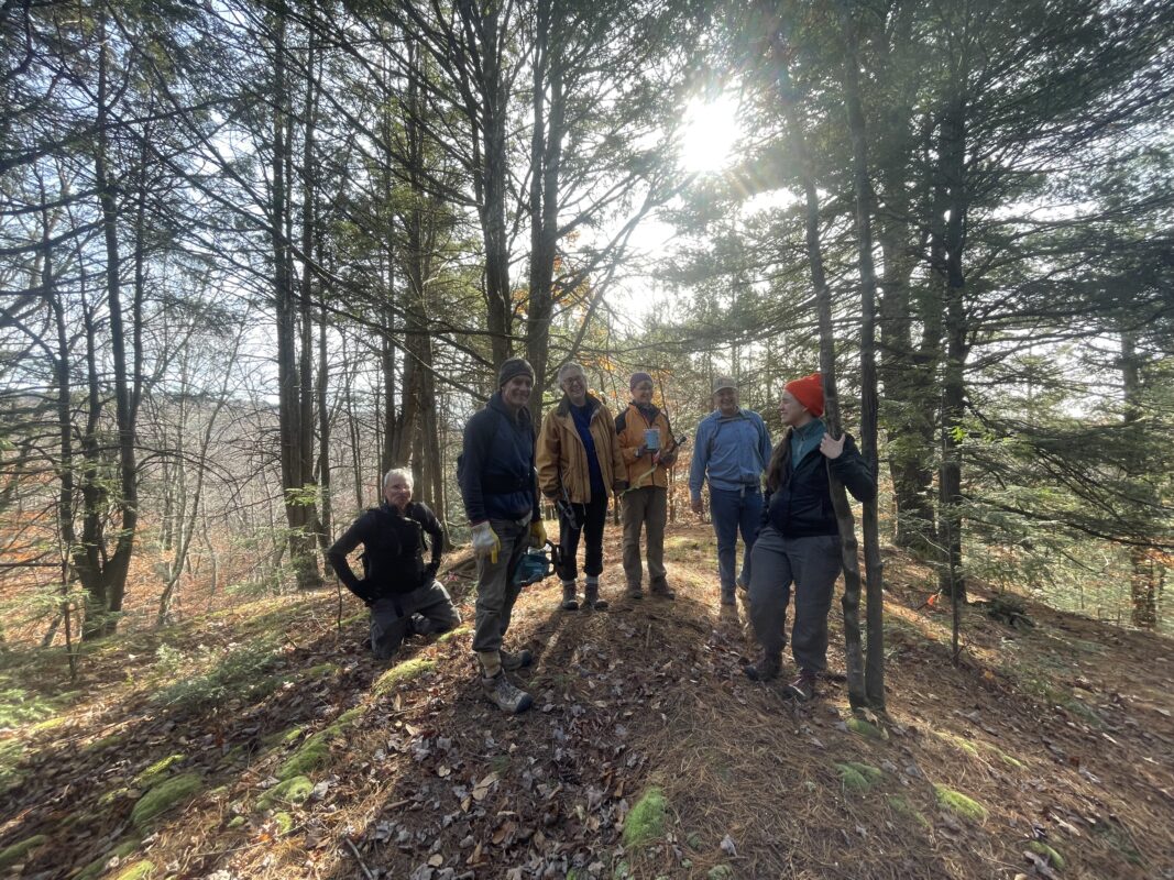
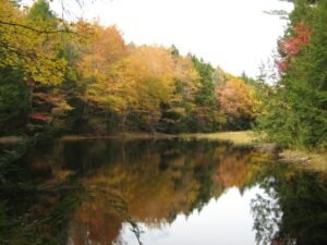
Featuring a diverse range of wildlife habitat including woods and wetlands, Conwell’s 2.5 miles of trails visit tranquil Conwell Pond, Eagle Nest Ridge, Jackson Swamp, and more. Keep an eye out for special surprises like old farm features, mink tracks, and beaver activity. Maintained trails are blazed in red and blue.

Seasonal hunting is permitted on the property subject to all state and town laws. Please take precautions while hiking.

The entire 175-acre property is open to the public following property guidelines.

  • Dogs must be kept on a leash when others are near. Owners must remove pet waste from the property.
  • Hunting is permitted subject to all state and town laws.
  • No camping or fires.
  • No motorized vehicles.
  • Please respect the privacy of our neighbors and remain on HLT land.
Photo shows the east side of Route 112 looking North from just south of the parking area. Text reading "parking area" accompanies an arrow pointing to the right and bottom of the image, while text reading "trail entrance" accompanies an arrow pointing in the upper left portion of the image.

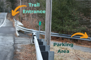
To access the property’s trails from the parking area, walk north on the shoulder of Route 112 (staying on the east side of the road) and enter the woods to your right just across the bridge over the Little River (see image). The Damway trail crosses a small stream and climbs over a modest hill before intersecting an old cart road. The Damway, Two Ponds Trail, and Eagle Nest Ridge Trail are blazed in red, and spur trails to Jackson Swamp and the top of Eagle Nest Ridge are blazed in blue. Unmaintained trails are not blazed so please follow the red and blue blazes and bring a copy of the map with you.

Note that there are no rest rooms or other facilities at this location.

Trail Map of the Conwell Property. Click image for larger version.
Conwell Trail Map

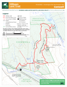
Parking & Directions

The parking area is on the east side of Route 112 just south of the 9.5 mile marker, and south of Higgins Road (note there is not a street sign). Route 112 crosses over the Little River just north of the parking area. Look for a break in the guardrail and a short, gravel driveway into the woods (see image). Use Google maps coordinates below for precise location.

Photo of parking area as seen from across Route 112. Text reading "break in guardrail" accompanies an arrow pointing to the location. Text reading "parking area" accompanies an arrow pointing to the parking area.

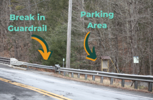
Travelling Southbound on Route 112: The parking area is approximately 5 miles south of Route 143. Look for the break in the guardrail on the lefthand side of the road just after you pass Higgins Road (note there is not a street sign) on the right.

Travelling Northbound on Route 112: The parking area is approximately 0.5 miles north of the intersection with Ireland Street and Thrasher Hill Road, at a break in the guardrail just before Route 112 crosses over the Little River.

Coordinates: 42.347512, -72.897667

6 volunteers, male and female, dressed in pants, jackets and hats are smiling at the camera while one looks off in the distance. They are standing at an opening in the forest with small pine and hemlock trees and the sun peaking through the trees in the background. Shadows are cast towards the camera.
Volunteers blazing the trail at the top of Eagle Nest Ridge

Events Calendar

Today
Sun
Mon
Tue
Wed
Thu
Fri
Sat
S
M
T
W
T
F
S
1
12:00 AM - Chesterfield Gorge Ultra & 25k
2
3
4
5
6
7
10:00 AM - Mill River Resilience Fair
8
9
10
11
12
13
14
15
16
17
18
19
20
21
22
23
24
25
26
27
28
29
30
1
2
3
4
5
Chesterfield Gorge Ultra & 25k
May 31st, 2025 - Jun 1st, 2025    
All Day
  • Partnership Event
  • Race
Join Hilltown Land Trust and Beast Coast Trail Running for the sixth-annual Chesterfield Gorge Ultra and 25k Race, including the only 100 mile race in [...]
More Info
Mill River Resilience Fair
Jun 7th, 2025    
10:00 am - 12:00 pm
  • Celebration
  • Family Fun
  • Hands-On
  • Kids
  • Partnership Event
Come out, meet your neighbors, and learn what the Williamsburg community is doing to become flood resilient. Activities for the whole family! Interactive stream table [...]
More Info
Events on Jun 1st, 2025
Chesterfield Gorge Ultra & 25k
31 May 25
Events on Jun 7th, 2025
Mill River Resilience Fair
7 Jun 25
  • About
    • Board & Committees
    • Staff and TerraCorps members
    • Affiliation with The Trustees
    • Announcements
    • Newsletters
    • Contact
    • Open Positions
  • Land Protection
    • Conservation Restrictions
    • Agricultural Preservation Restrictions
    • Financial Incentives
    • Donating or Selling Land
    • Estate Planning
    • Landowner & Town Resources
  • Properties
    • Trails & Maps
      • Big View Trail
      • Bradley
      • Breckenridge
      • Clary Hill
      • Conwell
      • Hilltown Boulders
      • Historic Dam Trail
      • Locke’s Loop Trail
      • Robert’s Meadow Brook Trail
      • Round Top Hill
      • Stevens
      • Two Mamas Farm Waterfall Trail
    • Land Stewardship
    • Conservation Stories
  • Get Involved
    • Events
    • Volunteer
    • Donate
    • Support
    • Legacy Giving
    • Gorge après Gorge
    • Vernal Pool Plunge

Learn

  • Announcements
  • Staff and TerraCorps members
  • Contact

Participate

  • Events
  • Volunteer
  • Donate
  • Subscribe

Hike

  • Bradley
  • Breckenridge
  • Stevens
Land Trust Accreditation seal
Contact Us
admin: Log in
© 2025 Hilltown Land Trust | Hilltown Land is a 501c3 nonprofit organization | Est. 1986