Donate
  • Events
  • Contact
  • Join Our Mailing List
  • Facebook
  • Instagram
  • LinkedIn
  • YouTube

Hilltown Land Trust

Dedicated to protecting the working lands, native habitats and rural beauty of the Hilltowns since 1986

  • About
    • Board & Committees
    • Staff and TerraCorps members
    • Affiliation with The Trustees
    • Announcements
    • Newsletters
    • Contact
    • Open Positions
  • Land Protection
    • Conservation Restrictions
    • Agricultural Preservation Restrictions
    • Financial Incentives
    • Donating or Selling Land
    • Estate Planning
    • Landowner & Town Resources
  • Properties
    • Trails & Maps
      • Big View Trail
      • Bradley
      • Breckenridge
      • Clary Hill
      • Conwell
      • Hilltown Boulders
      • Historic Dam Trail
      • Locke’s Loop Trail
      • Robert’s Meadow Brook Trail
      • Round Top Hill
      • Stevens
      • Two Mamas Farm Waterfall Trail
    • Land Stewardship
    • Conservation Stories
  • Get Involved
    • Events
    • Volunteer
    • Donate
    • Support
    • Legacy Giving
    • Gorge après Gorge
    • Vernal Pool Conservation
You are here: Home / Our Protected Lands

Our Protected Lands

Hilltown Land Trust has conserved over 5,000 acres of land in our 13-town service area. On this page, you can read about our conserved land, or you can view a map of protected lands in our service area or find information about hiking trails on our conserved properties.

Properties Owned by Hilltown Land Trust

Trail along Nichols Brook at the Bradley property

Bradley Sanctuary, Williamsburg: 41 acres with a 2 mile loop trail system. Gift of Oliver Bradley and Barbara Bradley Rust.
Click here for a trail map and more information. 

Breckenridge Sanctuary, Williamsburg: 67 acres with a 1 mile loop trail system. Gift of Margaret Breckenridge.
Click here for a trail map and more information.

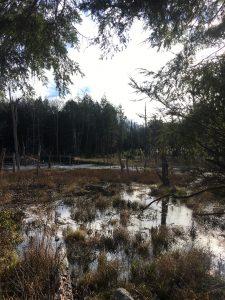
Jackson Swamp, Worthington: 110 landlocked acres without a public access easement. Gift of Karl Davies Sr.

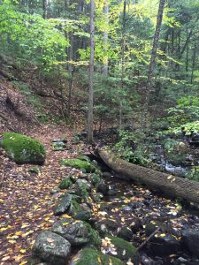
Stevens and Weiss, Huntington & Westhampton: Over 460 acres including nearly 5 miles of hiking trails. Much of this property was gifted by Frank Stevens. An adjacent 82 acres of forest land gifted by Dr. Nancy Weiss.
Click here for a trail map and more information.

Beaver pond on the Stevens property

Hastings, Worthington: 60+ acres of forest land on Prentice Road donated by Wilmont Hastings. There are currently no formal trails on this property.

Conwell, South Worthington: 70 acres of forest land with 3 miles of out-and-back trails. Gift of Cynthia Conwell Cook and Peter Cook. Click here for a trail map and more information.

Lashway, Westhampton: 145 acres of forest land on Hanging Mountain as well as over a mile of frontage along Robert’s Meadow Brook. This property is accessible from North Road, but there are currently no formal trails on the property.

Conservation Restrictions (CRs) held by Hilltown Land Trust

  • Hilltown Land Trust holds Conservation Restrictions for 35 privately owned properties and is adding more CRs each year.
  • Many of the landowners who have a Conservation Restriction with HLT have also opened sections of their properties to be used as hiking trails open to the public.
    • Taproot Commons Farm in Cummington has a short trail to a waterfall open to the public.
    • The Freedberg property, has two trails that lead to Round Top Hill, the highest elevation in Hampden County in Chester.
    • The Redwin property has a trail with views of Roberts Meadows Brook in Westhampton.

Agricultural Preservation Restrictions (APRs) and other projects facilitated by HLT*

Chucklebrook Farm, Worthington, MA

  • Krug Sugarbush, Chesterfield: 80 acres transferred to MA Department of Conservation and Recreation (DCR).
  • Long Pond, Chesterfield: 28 acres adjacent to Krug Sugarbush, also transferred to MA DCR.
  • Albert Airstrip Parcel APR, Worthington: 138 acres
  • Kellogg Farm APRs, Worthington: 250 acres
  • Chucklebrook Farm APR, Worthington: 80 acres
  • Big View Trail Voluntary Public Access easement in Williamsburg
  • Historic Dam Trail  Voluntary Public Access easement in Williamsburg

*Note, most APR projects are now managed directly by the MA Department of Agricultural Resources without the involvement of a third party such as a land trust.

Events Calendar

Today
Sun
Mon
Tue
Wed
Thu
Fri
Sat
S
M
T
W
T
F
S
30
1
2
3
4
5
6
7
8
9
10
11
12
13
14
15
16
17
18
19
20
21
22
23
24
25
26
27
28
29
30
31
1
2
3
  • About
    • Board & Committees
    • Staff and TerraCorps members
    • Affiliation with The Trustees
    • Announcements
    • Newsletters
    • Contact
    • Open Positions
  • Land Protection
    • Conservation Restrictions
    • Agricultural Preservation Restrictions
    • Financial Incentives
    • Donating or Selling Land
    • Estate Planning
    • Landowner & Town Resources
  • Properties
    • Trails & Maps
      • Big View Trail
      • Bradley
      • Breckenridge
      • Clary Hill
      • Conwell
      • Hilltown Boulders
      • Historic Dam Trail
      • Locke’s Loop Trail
      • Robert’s Meadow Brook Trail
      • Round Top Hill
      • Stevens
      • Two Mamas Farm Waterfall Trail
    • Land Stewardship
    • Conservation Stories
  • Get Involved
    • Events
    • Volunteer
    • Donate
    • Support
    • Legacy Giving
    • Gorge après Gorge
    • Vernal Pool Conservation

Learn

  • Announcements
  • Staff and TerraCorps members
  • Contact

Participate

  • Events
  • Volunteer
  • Donate
  • Subscribe

Hike

  • Bradley
  • Breckenridge
  • Stevens
Land Trust Accreditation seal
Contact Us
admin: Log in
© 2026 Hilltown Land Trust | Hilltown Land is a 501c3 nonprofit organization | Est. 1986
Manage Consent
To provide the best experiences, we use technologies like cookies to store and/or access device information. Consenting to these technologies will allow us to process data such as browsing behavior or unique IDs on this site. Not consenting or withdrawing consent, may adversely affect certain features and functions.
Functional Always active
The technical storage or access is strictly necessary for the legitimate purpose of enabling the use of a specific service explicitly requested by the subscriber or user, or for the sole purpose of carrying out the transmission of a communication over an electronic communications network.
Preferences
The technical storage or access is necessary for the legitimate purpose of storing preferences that are not requested by the subscriber or user.
Statistics
The technical storage or access that is used exclusively for statistical purposes. The technical storage or access that is used exclusively for anonymous statistical purposes. Without a subpoena, voluntary compliance on the part of your Internet Service Provider, or additional records from a third party, information stored or retrieved for this purpose alone cannot usually be used to identify you.
Marketing
The technical storage or access is required to create user profiles to send advertising, or to track the user on a website or across several websites for similar marketing purposes.
  • Manage options
  • Manage services
  • Manage {vendor_count} vendors
  • Read more about these purposes
View preferences
  • {title}
  • {title}
  • {title}