Donate
  • Events
  • Contact
  • Join Our Mailing List
  • Facebook
  • Instagram
  • LinkedIn
  • YouTube

Hilltown Land Trust

Dedicated to protecting the working lands, native habitats and rural beauty of the Hilltowns since 1986

  • About
    • Board & Committees
    • Staff and TerraCorps members
    • Affiliation with The Trustees
    • Announcements
    • Newsletters
    • Contact
    • Open Positions
  • Land Protection
    • Conservation Restrictions
    • Agricultural Preservation Restrictions
    • Financial Incentives
    • Donating or Selling Land
    • Estate Planning
    • Landowner & Town Resources
  • Properties
    • Trails & Maps
      • Big View Trail
      • Bradley
      • Breckenridge
      • Clary Hill
      • Conwell
      • Hilltown Boulders
      • Historic Dam Trail
      • Locke’s Loop Trail
      • Robert’s Meadow Brook Trail
      • Round Top Hill
      • Stevens
      • Two Mamas Farm Waterfall Trail
    • Land Stewardship
    • Conservation Stories
  • Get Involved
    • Events
    • Volunteer
    • Donate
    • Support
    • Legacy Giving
    • Gorge après Gorge
    • Vernal Pool Conservation
You are here: Home / Protected Lands post archive / Hiking Trails and Maps / Hilltown Boulders

Hilltown Boulders

Margaret Waggoner, seen from behind, walks along a path in the woods using a walking stick. She is dressed in jeans and a red top with a red vest. Next to her is a long rock wall, and she is surrounded by autumn leaves on the trees.

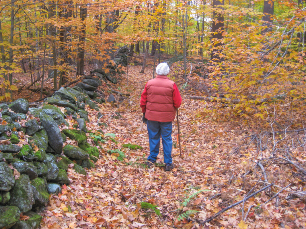
Conservation restriction donor Margaret Waggoner in her woods.

At the Hilltown Boulders, you’ll find yourself feeling small next to all the glacial erratics dotting the woods. As you walk along the gently sloping trail, you’ll also pass built stone features, a field of quartz, huge branching wolf pines, and the outskirts of the 100-acre Sears Meadow wetland.

A lush verdant wetland, seen from a bird's-eye drone view.

A resilient landscape

Conserved forests and wetlands at the Hilltown Boulders buffer against climate change by:

  • Safeguarding water quality
  • Providing plant and wildlife habitat
  • Storing carbon

Sears Meadow, which is partially conserved by Hilltown Land Trust at the Boulders. Photo by Bob Labrie.

Trails

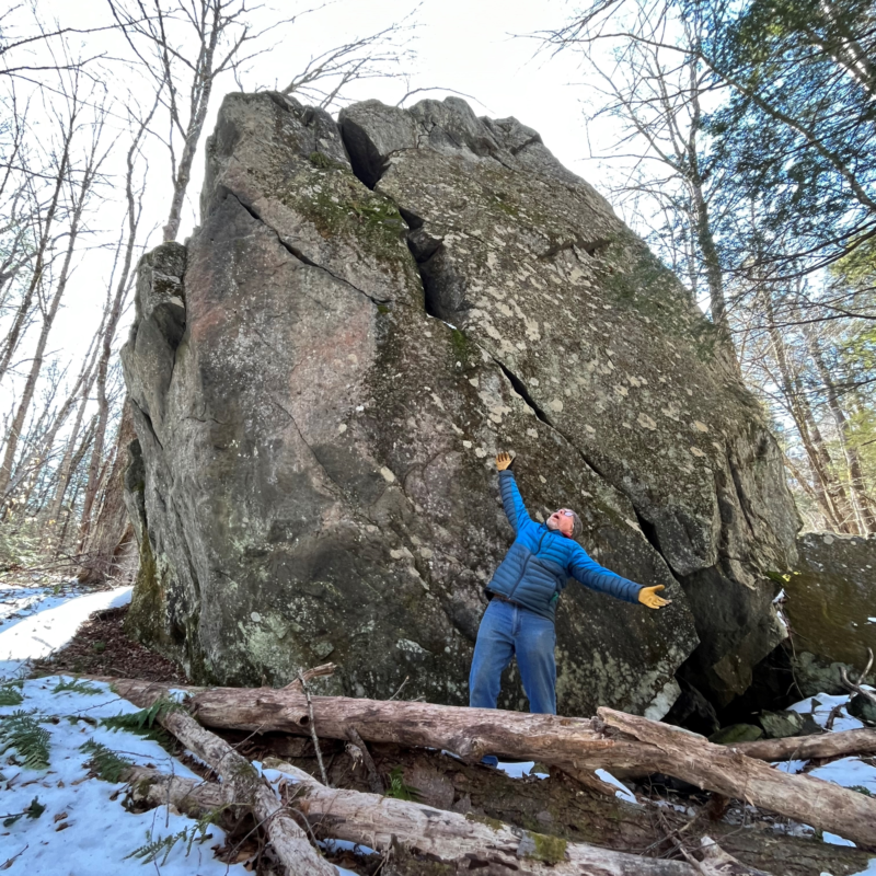
The trail system is made up of two three-quarter mile loops off Sears Road: the Sentry Loop to the north and the Saxifrage Loop to the south, with a short connector trail between. One trail spur off the Sentry Loop leads to RT 112 (no parking), where the DAR State Forest can be accessed via an unofficial trail to the north. Another spur off the Saxifrage Loop leads to the Split Rock. All 1.8 miles of maintained trails are marked with Ashfield Trails medallions. 

The trails are on private property protected by a conservation restriction held by Hilltown Land Trust. Hilltown Land Trust has collaborated with Ashfield Trails on the management of these trails.  

Note that there are no restrooms or other facilities at this location. 

Property Guidelines

The trails are open to the public following property guidelines: 

  • Dogs must be kept on a leash when others are near. Owners must remove pet waste from the property.
  • Hunting is permitted subject to all state and town laws.
  • No camping or fires.
  • No motorized vehicles.
  • Please respect the privacy of residents and neighbors and remain on maintained trails.
  • Park only in designated spots and not along the road.

Public access is open from dawn until dusk.

A warmly dressed man poses with his arms flung open, gazing up at a giant snow-ringed boulder.

Trail Map

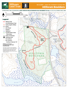
Trail map of the Hilltown Boulders. Click for a larger version.

Boulders Trail Map

Parking & Directions 

The parking area and trailhead are on the southeast side of Sears Rd in Ashfield. Two cars can fit in the parking area. Do not park along the road.

Traveling Northbound on RT 112

Take a left on Sears Rd, approximately 2.5 miles north of RT 9 in Goshen. Travel down Sears Rd for 0.4 mile. At a sharp bend to the right, you will see the trailhead and a small parking area on the left. Do not park along the road. Additional parking is in a plowed area 1/3 mile south of the trail entrance (away from RT 112) at the Ashfield-Goshen town line. 

Traveling Eastbound on RT 9

Take a left on Sears Rd, 4.5 miles from Main St in Cummington. Travel up Sears Rd for 1.8 miles and look for the trailhead and a small parking area on the right. Do not park along the road. Additional parking is in a plowed area 1/3 mile south of the trail entrance (away from RT 112) at the Ashfield-Goshen town line.

Attention!

Out of courtesy for neighbors and plows, do not park along the road near the trail entrance without permission. Additional parking is available 1/3 of a mile south of the trail entrance (away from RT 112) at the Ashfield-Goshen town line in a plowed parking area off Sears Rd. 

Silhouettes of the HLT logo bear and cub.

Events Calendar

Today
Sun
Mon
Tue
Wed
Thu
Fri
Sat
S
M
T
W
T
F
S
26
27
28
29
30
1
2
3
4
5
6
7
8
9
10
11
12
13
14
15
16
10:00 AM - Spring Wildflower Interpretive Walk
17
10:00 AM - Salad & Herb Gardening 101
18
19
20
21
22
23
24
25
26
27
28
29
30
31
1
2
3
4
5
6
Spring Wildflower Interpretive Walk
16 May
May 16th, 2015    
10:00 am - 12:00 pm
Chapel Brook Reservation
  • Hands-On
  • Hike
  • Partnership Event
Spring Wildflower Walk Saturday, May 16 | 10am –12pm Location: Chapel Brook Reservation Come enjoy a mid-morning interpretive walk through a rich mesic forest of [...]
More Info
Salad & Herb Gardening 101
17 May
May 17th, 2015    
10:00 am - 12:00 pm
The Countryside Community Garden
  • Hands-On
  • Partnership Event
  • Workshop
Add excitement to your meals with some herbs from your very own kitchen garden! This workshop will overview how to start herbs from seed, grow [...]
More Info
Events on May 16th, 2015
16 May
Spring Wildflower Interpretive Walk
16 May 15
Williamsburg
Events on May 17th, 2015
17 May
Salad & Herb Gardening 101
17 May 15
Russell
  • About
    • Board & Committees
    • Staff and TerraCorps members
    • Affiliation with The Trustees
    • Announcements
    • Newsletters
    • Contact
    • Open Positions
  • Land Protection
    • Conservation Restrictions
    • Agricultural Preservation Restrictions
    • Financial Incentives
    • Donating or Selling Land
    • Estate Planning
    • Landowner & Town Resources
  • Properties
    • Trails & Maps
      • Big View Trail
      • Bradley
      • Breckenridge
      • Clary Hill
      • Conwell
      • Hilltown Boulders
      • Historic Dam Trail
      • Locke’s Loop Trail
      • Robert’s Meadow Brook Trail
      • Round Top Hill
      • Stevens
      • Two Mamas Farm Waterfall Trail
    • Land Stewardship
    • Conservation Stories
  • Get Involved
    • Events
    • Volunteer
    • Donate
    • Support
    • Legacy Giving
    • Gorge après Gorge
    • Vernal Pool Conservation

Learn

  • Announcements
  • Staff and TerraCorps members
  • Contact

Participate

  • Events
  • Volunteer
  • Donate
  • Subscribe

Hike

  • Bradley
  • Breckenridge
  • Stevens
Land Trust Accreditation seal
Contact Us
admin: Log in
© 2026 Hilltown Land Trust | Hilltown Land is a 501c3 nonprofit organization | Est. 1986