Donate
  • Events
  • Contact
  • Join Our Mailing List
  • Facebook
  • Instagram
  • LinkedIn
  • YouTube

Hilltown Land Trust

Dedicated to protecting the working lands, native habitats and rural beauty of the Hilltowns since 1986

  • About
    • Board & Committees
    • Staff and TerraCorps members
    • Affiliation with The Trustees
    • Announcements
    • Newsletters
    • Contact
    • Open Positions
  • Land Protection
    • Conservation Restrictions
    • Agricultural Preservation Restrictions
    • Financial Incentives
    • Donating or Selling Land
    • Estate Planning
    • Landowner & Town Resources
  • Properties
    • Trails & Maps
      • Big View Trail
      • Bradley
      • Breckenridge
      • Clary Hill
      • Conwell
      • Hilltown Boulders
      • Historic Dam Trail
      • Locke’s Loop Trail
      • Robert’s Meadow Brook Trail
      • Round Top Hill
      • Stevens
      • Two Mamas Farm Waterfall Trail
    • Land Stewardship
    • Conservation Stories
  • Get Involved
    • Events
    • Volunteer
    • Donate
    • Support
    • Legacy Giving
    • Gorge après Gorge
    • Vernal Pool Conservation
You are here: Home / Hiking at the Conwell Property

Hiking at the Conwell Property

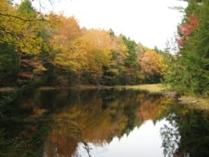
Pond in the center of the property is still with trees and the sky reflecting. The foliage is colorful with some reds, yellows, oranges, and greens seen in the trees around the pond. At the edge of the pond you can see small grasses alluding to a different wetland habitat.
Conwell Pond with fall foliage

Featuring a diverse range of wildlife habitat including woods and wetlands, Conwell’s 2.5 miles of trails visit tranquil Conwell Pond, Eagle Nest Ridge, Jackson Swamp, and more. Keep an eye out for special surprises like old farm features, mink tracks, and beaver activity. Maintained trails are blazed in red and blue.

Seasonal hunting is permitted on the property subject to all state and town laws. Please take precautions while hiking.

The entire 175-acre property is open to the public following property guidelines.

  • Dogs must be kept on a leash when others are near. Owners must remove pet waste from the property.
  • Hunting is permitted subject to all state and town laws.
  • No camping or fires.
  • No motorized vehicles.
  • Please respect the privacy of our neighbors and remain on HLT land.
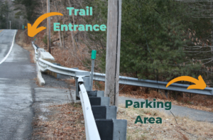
Photo shows the east side of Route 112 looking North from just south of the parking area. Text reading "parking area" accompanies an arrow pointing to the right and bottom of the image, while text reading "trail entrance" accompanies an arrow pointing in the upper left portion of the image.

To access the property’s trails from the parking area, walk north on the shoulder of Route 112 (staying on the east side of the road) and enter the woods to your right just across the bridge over the Little River (see image). The Damway trail crosses a small stream and climbs over a modest hill before intersecting an old cart road. The Damway, Two Ponds Trail, and Eagle Nest Ridge Trail are blazed in red, and spur trails to Jackson Swamp and the top of Eagle Nest Ridge are blazed in blue. Unmaintained trails are not blazed so please follow the red and blue blazes and bring a copy of the map with you.

Note that there are no rest rooms or other facilities at this location.
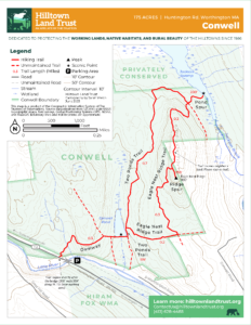
Trail Map of the Conwell Property. Click image for larger version.
Conwell Trail Map

Parking & Directions

The parking area is on the east side of Route 112 just south of the 9.5 mile marker, and south of Higgins Road (note there is not a street sign). Route 112 crosses over the Little River just north of the parking area. Look for a break in the guardrail and a short, gravel driveway into the woods (see image). Use Google maps coordinates below for precise location.
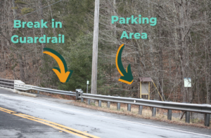
Photo of parking area as seen from across Route 112. Text reading "break in guardrail" accompanies an arrow pointing to the location. Text reading "parking area" accompanies an arrow pointing to the parking area.

Travelling Southbound on Route 112: The parking area is approximately 5 miles south of Route 143. Look for the break in the guardrail on the lefthand side of the road just after you pass Higgins Road (note there is not a street sign) on the right.

Travelling Northbound on Route 112: The parking area is approximately 0.5 miles north of the intersection with Ireland Street and Thrasher Hill Road, at a break in the guardrail just before Route 112 crosses over the Little River.

Coordinates: 42.347512, -72.897667
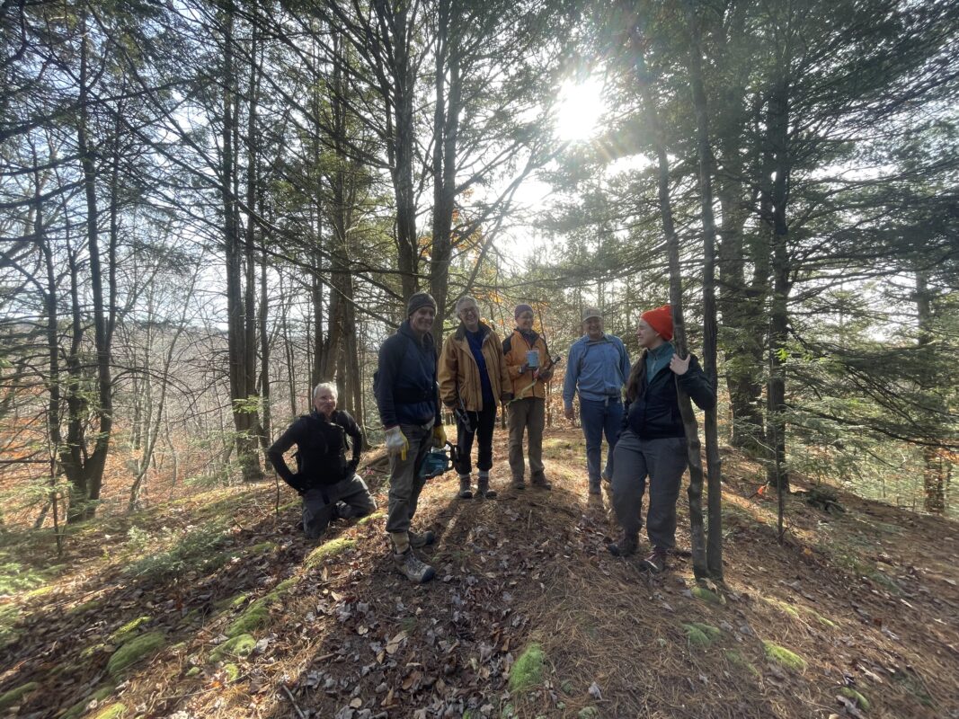
6 volunteers, male and female, dressed in pants, jackets and hats are smiling at the camera while one looks off in the distance. They are standing at an opening in the forest with small pine and hemlock trees and the sun peaking through the trees in the background. Shadows are cast towards the camera.
Volunteers blazing the trail at the top of Eagle Nest Ridge

Events Calendar

Today
Sun
Mon
Tue
Wed
Thu
Fri
Sat
S
M
T
W
T
F
S
1
2
3
4
5
6
7
6:00 PM - Vernal Pools and their ephemeral gifts
8
9
10
11
10:00 AM - Senior Hike with All Out Adventures
12
13
14
15
16
17
18
19
20
21
22
23
24
25
26
6:00 PM - Postponed - Network for Local Land Conservation- Hampshire & Hampden County
27
28
29
30
5:00 PM - Postponed -- Bear Hair Snare Research and Wildlife Cam Presentation
31
1
2
3
4
Vernal Pools and their ephemeral gifts
Mar 7th, 2020    
6:00 pm - 8:30 pm
Stanton Hall
  • Celebration
  • Partnership Event
  • Training
Would you like to learn more about the critters living in the pools in the woods behind your house? Would you like to protect this [...]
More Info
Senior Hike with All Out Adventures
Mar 11th, 2020    
10:00 am - 2:00 pm
DAR State Forest
  • Hike
  • Partnership Event
Hilltown Land Trust is partnering up with All Out Adventures to offer a Senior Hike at the DAR State Forest in Goshen! Come enjoy this [...]
More Info
Postponed - Network for Local Land Conservation- Hampshire & Hampden County
Mar 26th, 2020    
6:00 pm - 8:30 pm
Stanton Hall
THIS EVENT IS POSTPONED UNTIL FURTHER NOTICE. Concerns about attending public events due to the Corona Virus has indicated that we should postpone this networking [...]
More Info
Postponed -- Bear Hair Snare Research and Wildlife Cam Presentation
Mar 30th, 2020    
5:00 pm - 7:00 pm
Meekins Library
THIS EVENT IS POSTPONED UNTIL FURTHER NOTICE. We hope to reschedule the event at a later date but are currently concerned about your safety even [...]
More Info
Events on Mar 7th, 2020
Vernal Pools and their ephemeral gifts
7 Mar 20
Huntington
Events on Mar 11th, 2020
Senior Hike with All Out Adventures
11 Mar 20
Goshen
Events on Mar 26th, 2020
Postponed - Network for Local Land Conservation- Hampshire & Hampden County
26 Mar 20
Huntington
Events on Mar 30th, 2020
Postponed -- Bear Hair Snare Research and Wildlife Cam Presentation
30 Mar 20
Williamsburg
  • About
    • Board & Committees
    • Staff and TerraCorps members
    • Affiliation with The Trustees
    • Announcements
    • Newsletters
    • Contact
    • Open Positions
  • Land Protection
    • Conservation Restrictions
    • Agricultural Preservation Restrictions
    • Financial Incentives
    • Donating or Selling Land
    • Estate Planning
    • Landowner & Town Resources
  • Properties
    • Trails & Maps
      • Big View Trail
      • Bradley
      • Breckenridge
      • Clary Hill
      • Conwell
      • Hilltown Boulders
      • Historic Dam Trail
      • Locke’s Loop Trail
      • Robert’s Meadow Brook Trail
      • Round Top Hill
      • Stevens
      • Two Mamas Farm Waterfall Trail
    • Land Stewardship
    • Conservation Stories
  • Get Involved
    • Events
    • Volunteer
    • Donate
    • Support
    • Legacy Giving
    • Gorge après Gorge
    • Vernal Pool Conservation

Learn

  • Announcements
  • Staff and TerraCorps members
  • Contact

Participate

  • Events
  • Volunteer
  • Donate
  • Subscribe

Hike

  • Bradley
  • Breckenridge
  • Stevens
Land Trust Accreditation seal
Contact Us
admin: Log in
© 2026 Hilltown Land Trust | Hilltown Land is a 501c3 nonprofit organization | Est. 1986
Manage Consent
To provide the best experiences, we use technologies like cookies to store and/or access device information. Consenting to these technologies will allow us to process data such as browsing behavior or unique IDs on this site. Not consenting or withdrawing consent, may adversely affect certain features and functions.
Functional Always active
The technical storage or access is strictly necessary for the legitimate purpose of enabling the use of a specific service explicitly requested by the subscriber or user, or for the sole purpose of carrying out the transmission of a communication over an electronic communications network.
Preferences
The technical storage or access is necessary for the legitimate purpose of storing preferences that are not requested by the subscriber or user.
Statistics
The technical storage or access that is used exclusively for statistical purposes. The technical storage or access that is used exclusively for anonymous statistical purposes. Without a subpoena, voluntary compliance on the part of your Internet Service Provider, or additional records from a third party, information stored or retrieved for this purpose alone cannot usually be used to identify you.
Marketing
The technical storage or access is required to create user profiles to send advertising, or to track the user on a website or across several websites for similar marketing purposes.
  • Manage options
  • Manage services
  • Manage {vendor_count} vendors
  • Read more about these purposes
View preferences
  • {title}
  • {title}
  • {title}