Donate
  • Events
  • Contact
  • Join Our Mailing List
  • Facebook
  • Instagram
  • LinkedIn
  • YouTube

Hilltown Land Trust

Dedicated to protecting the working lands, native habitats and rural beauty of the Hilltowns since 1986

  • About
    • Board & Committees
    • Staff and TerraCorps members
    • Affiliation with The Trustees
    • Announcements
    • Newsletters
    • Contact
    • Open Positions
  • Land Protection
    • Conservation Restrictions
    • Agricultural Preservation Restrictions
    • Financial Incentives
    • Donating or Selling Land
    • Estate Planning
    • Landowner & Town Resources
  • Properties
    • Trails & Maps
      • Big View Trail
      • Bradley
      • Breckenridge
      • Clary Hill
      • Conwell
      • Hilltown Boulders
      • Historic Dam Trail
      • Locke’s Loop Trail
      • Robert’s Meadow Brook Trail
      • Round Top Hill
      • Stevens
      • Two Mamas Farm Waterfall Trail
    • Land Stewardship
    • Conservation Stories
  • Get Involved
    • Events
    • Volunteer
    • Donate
    • Support
    • Legacy Giving
    • Gorge après Gorge
    • Vernal Pool Plunge
You are here: Home / Announcements / Planning for a Resilient Mill River

Planning for a Resilient Mill River

March 28, 2024

A man looks down from a concrete and metal road bridge towards a channeled river below.
Studying the Mill River in Haydenville. Photo by Mark Costa of project partner VHB.

Last year, climate change-driven flooding wreaked havoc on homes, farms, roads, bridges, and livelihoods across the Northeast. In October, the town of Williamsburg embarked on a two-year $682,085 state Municipal Vulnerability Preparedness action grant to study flood resilience in the Upper Mill River watershed. HLT is tasked with engaging the Williamsburg community and surrounding Hilltowns in this pursuit.

This MVP grant is an important piece of critical resilience planning in the Hilltowns. The grant helps us learn what the Upper Mill River watershed needs by studying the river, reviewing climate and ecological data, and talking to the community. By incorporating community knowledge, this planning will ensure more effective future infrastructure upgrades and flood interventions.

What’s our Watershed?

All the land where rainfall, streams, and rivers eventually flow into the Mill River north of the Northampton line. (That’s most of Williamsburg, plus parts of Goshen, Westhampton, Chesterfield, Ashfield, Conway, and Whately.)

So far, our team has used this grant to study:

  • Culverts and stormwater infrastructure
  • Wildlife corridors, soils, climate data, and carbon storage
  • Floodwater storage assessment
  • Outreach to boards and committees in watershed towns
  • Mapping the watershed
  • And more!

What’s coming up:

  • Indigenous consultation and site visits with No Loose Braids
  • Opportunities for public input through events and surveys
  • Ways to connect and learn more about the project online

Ways to Engage

We want you to join us as we plan for a safe, resilient Upper Mill River watershed!

Survey: Land Management for Climate Resilience in the Upper Mill River Watershed

Do you care for or own land in the Upper Mill River Watershed? We want to hear from you about your land management practices and how we can support you. Click here to send your thoughts in a survey from our project partner Dodson and Flinker.

Take the Survey
On a blue waterdrop background, turquoise and white text reads "Climate Smart Workshops at Home and Work at  Meekins Library Williamsburg, MA, Saturdays, 9-10:30 am." A list of session dates reads "March 30th, Mapping Stormflows at Home and Work. April 6th, Soak Up the Rain: It’s All About the Soil. April 13th, Harvesting Rainwater: Cisterns and Rain Barrels. April 27th, Soak Up the Rain: Rain Gardens and Bioswales. May 4th, Soak Up the Rain: Porous Paving." At the very bottom, there are partner logos of Hilltown Land Trust, the Town of Williamsburg, Pioneer Valley Planning Commission, and Meekins Library.

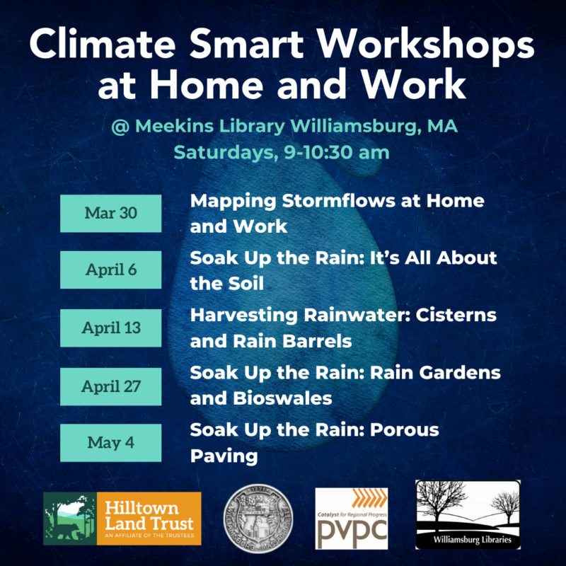
Climate Smart Landscapes at Home and Work

Learn simple backyard flood interventions you can do yourself in this practical workshop series.

Saturdays 9-10:30 am @ Williamsburg Meekins Library | March 30, April 6, April 13, April 27, May 4

Mill River Flood 150th Commemoration

Williamsburg & Leeds, Saturday May 18th

Tell us how you want to get involved!

Questions? Input? Want to join us in building local resiliency? Drop us a line at sarah@hilltownlandtrust.org or call (413) 628-4485 ext. 6!

The logos of the town of Williamsburg, Mill River Greenway Initiative, No Loose Braids, Executive Office of Environmental Affairs, VHB, Pioneer Valley Planning Commission, Hilltown Land Trust, Williamsburg residents and businesses, Dodson and Flinker, and the Anne T Dunphy School.

Filed Under: Announcements, Newsletter

Events Calendar

Today
Sun
Mon
Tue
Wed
Thu
Fri
Sat
S
M
T
W
T
F
S
29
30
1
2
3
4
5
6
7
8
9
10
11
12
13
14
15
16
17
18
19
20
21
22
4:00 PM - Create a Lasting Legacy Workshop: How to Support the Causes You Love
23
24
25
26
27
28
29
2:00 PM - What’s in a Forest Assessment? Meet a Forester Woods Walk
30
31
1
2
Create a Lasting Legacy Workshop: How to Support the Causes You Love
Oct 22nd, 2024    
4:00 pm - 5:00 pm
  • Training
  • Webinar
We invite you to join us during National Estate Planning Awareness Week for a FREE Zoom workshop with Attorney Valerie Vignaux. Hilltown Land Trust is [...]
More Info
What’s in a Forest Assessment? Meet a Forester Woods Walk
Oct 29th, 2024    
2:00 pm - 4:00 pm
Unquomonk Town Water Land
  • Hands-On
  • Hike
  • Workshop
Join us on a walk at Williamsburg Town Water Department land with Licensed Forester Ry Patton (Bay State Forestry) and Hilltown Land Trust land stewardship [...]
More Info
Events on Oct 22nd, 2024
Create a Lasting Legacy Workshop: How to Support the Causes You Love
22 Oct 24
Events on Oct 29th, 2024
What’s in a Forest Assessment? Meet a Forester Woods Walk
29 Oct 24
Williamsburg
  • About
    • Board & Committees
    • Staff and TerraCorps members
    • Affiliation with The Trustees
    • Announcements
    • Newsletters
    • Contact
    • Open Positions
  • Land Protection
    • Conservation Restrictions
    • Agricultural Preservation Restrictions
    • Financial Incentives
    • Donating or Selling Land
    • Estate Planning
    • Landowner & Town Resources
  • Properties
    • Trails & Maps
      • Big View Trail
      • Bradley
      • Breckenridge
      • Clary Hill
      • Conwell
      • Hilltown Boulders
      • Historic Dam Trail
      • Locke’s Loop Trail
      • Robert’s Meadow Brook Trail
      • Round Top Hill
      • Stevens
      • Two Mamas Farm Waterfall Trail
    • Land Stewardship
    • Conservation Stories
  • Get Involved
    • Events
    • Volunteer
    • Donate
    • Support
    • Legacy Giving
    • Gorge après Gorge
    • Vernal Pool Plunge

Learn

  • Announcements
  • Staff and TerraCorps members
  • Contact

Participate

  • Events
  • Volunteer
  • Donate
  • Subscribe

Hike

  • Bradley
  • Breckenridge
  • Stevens
Land Trust Accreditation seal
Contact Us
admin: Log in
© 2025 Hilltown Land Trust | Hilltown Land is a 501c3 nonprofit organization | Est. 1986